


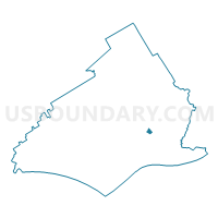
RUTLEDGE Voting District, Delaware County, Pennsylvania
About
Outline

Summary
| Unique Area Identifier | 659203 |
| Name | RUTLEDGE Voting District |
| County | Delaware County |
| State | Pennsylvania |
| Area (square miles) | 0.14 |
| Land Area (square miles) | 0.14 |
| Water Area (square miles) | 0.00 |
| % of Land Area | 100.00 |
| % of Water Area | 0.00 |
| Latitude of the Internal Point | 39.90094850 |
| Longtitude of the Internal Point | -75.32742240 |
Maps

Graphs
Select a template below for downloading or customizing gragh for RUTLEDGE Voting District, Delaware County, Pennsylvania


Neighbors
Neighoring Voting District (by Name) Neighboring Voting District on the Map
- MORTON Voting District, Delaware County, PA
- RIDLEY TWP WD 03 PCT 01, Delaware County, PA
- RIDLEY TWP WD 08 PCT 01, Delaware County, PA
Top 10 Neighboring County Subdivision (by Population) Neighboring County Subdivision on the Map
- Ridley township, Delaware County, PA (30,768)
- Morton borough, Delaware County, PA (2,669)
- Rutledge borough, Delaware County, PA (784)
Top 10 Neighboring Place (by Population) Neighboring Place on the Map
Top 10 Neighboring Unified School District (by Population) Neighboring Unified School District on the Map
- Ridley School District, PA (40,180)
- Springfield School District, PA (26,880)
- Wallingford-Swarthmore School District, PA (21,597)